

The area is rich in gold mining history, beginning in 1910.
Anvil Creek consists of 860 acres and Ophir Creek consists of 720 acres for a total of 1580 acres
Anvil Creek is around 2 1/2 miles long.
5,000 lineal feet of creek channel left to be placer mined, along with 2 other known paystreaks – Innoko Flats and Anvil Benches on the claims.
There is 2,500 feet of Innoko River frontage and a 1,500 foot gravel airstrip.
Permits are all current, ponds, ditches, and dams are in place and there is active mining.
The average gold fineness is 878 parts gold and 117 parts of silver in a thousand.
Ophir Creek Claims are located on approximately 2 1/2 miles of Ophir Creek with over 2 miles of tailings from the early-mid 1900’s available for mining (no overburden to remove). There is also gold to be found on the benches.
Permits are all current, ponds, ditches, and dams are in place and there is active mining.
The average gold fineness is 898 parts gold.
250 air miles west of Anchorage
30 air miles west of McGrath
Includes Anvil Creek Claims and Ophir Creek Claims
50 miles of road from Ophir to the Kuskokwim River (barge service available for fuel, equipment and supplies)
The Ophir/Innoko Mining District has many geological reports written on it and many can be found online.
https://mrdata.usgs.gov/ardf/show-ardf.php?ardf_num=OP030
https://mrdata.usgs.gov/ardf/show-ardf.php?ardf_num=OP025
Current owner of Anvil Creek has had the property for over 30 years. He is willing to help new owners with consultations and support during their first year.
1 – 375 Cat Excavator
1 – D8 N Cat Dozer
1 – Alaska Goldfield Engineering Trommel (230 yds/hr) with sluice boxes
3 – 40’ Conveyors (1 in need of repairs)
2 – 20’ Conveyors (new)
1 – John Deere Loader
1 – 10” x 8” Pump – 3000 gal/min. 3208 12volt 175hp
1 – 8” x 8” 4 cylinder Cat Pump – 1500 gals./min. (pony motor)
1 – Cat 304CR Mini-Excavator with 6” & 12” buckets
1 – 5’ x 12’ Shaker Screen
1 – 6” Auger Drill – V4 gas Wisconsin
2 – Bobcats
Over 10 fuel tanks from 6,000 gallons down to 130 gallons
300-500 sq. ft. fuel containment liner
1 – Sluice Box Assembly – 24” x 30’
1 – No. 1 Hand Giant (water nozzle)
1 – Pump Box
1 – Pipe Trailer
2000’ total of aluminum pipe (8” and 6”) with a variety of associated fittings
Variety of steel pipe with associated fittings
2 – Vibrating Sluice Boxes for fine gold recovery
1 – Screening Machine for cleanup
1 – Gold Cube
1 – 4’ x 8’ cleanup table (new)
1 – Doodlebug (mini clean-up trommel)
1 – Gold Wheel
1 – Propane Forge
Various screens, pans, and scales
Shop is fully equipped with a lathe, drill press, air compressor, various power tools, hand tools, wrenches, and sockets, and miscellaneous extras.
Lincoln Welder with plasma cutter and wire feed
Four diesel generators – 100 kw, 50kw, 9kw , and 6kw
Note: Located on Anvil Creek
3-Bedroom house with bath and all the furnishings
1-Bedroom cabin with bath and all the furnishings
Cookshack with 2 refrigerators, 3 freezers, microwave, range, dishwasher, washer, dryer, and all the cooking and eating utensils
Large laundry room/mud room, bathroom, and bedroom connecting to the cookshack
Large Shop with attached generator room
4 Storage buildings, one with a bunk house upstairs
1 – 12’ x 12’ x 10’ high Metal Building (insulated and double walled)
2 – 20’ Enclosed Containers
2 – 20’ Open Skids
Camp water is stored in a 500 gallon tank located inside laundry room facility
Self-contained water system supplies water to the cookshack, cabin, and house
30 gallon oil-fired hot water heater
All camp buildings have oil stoves
Camp has a variety of lighting sources, with all buildings having elec. lights and some buildings having propane and 12 volt lights
Ophir Creek has been mined for about 2 1/2 miles above its mouth, near the town of Ophir on the Innoko River. Mining also took place near its head. The coordinates are for the approximate midpoint of mine tailings marked on the U.S. Geological Survey Ophir A-2 topographic map (1954, minor revisions 1965). This point is on lower Ophir Creek, in sec. 26, T. 27 S., R. 12 E., Kateel River Meridian. Ophir Creek corresponds to localities 13 and 14 of Cobb (1972 [MF 367]). The location is accurate.
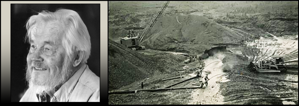
Toivo Johan Gustavus Rosander, known to friends and family simply as ‘Toivo’, was born on December 30th, 1915 in Kukkola, Finland. He passed away in a suburb of Miami, Florida on December 24th, 2010—just missing his 95th birthday by a few days.
Toivo lived in the mining town of Ophir and worked alongside Eric Hard, his uncle Gus, Cole McFarland Sr., Hugh Matheson Sr. and Joe Degnan. Ophir, named for the fabled place where the Queen of Sheba’s mines were located, was the center of mining in the Innoko district and miners from Ganes, Yankee, Little, Spruce, Ester, and Ophir Creeks did their business there.
Pictured above is the Uotila and Hard placer operation on Ophir Creek, where Toivo worked circa 1937
Anvil Creek is a 2.5-mile-long, northeast-flowing tributary to the Innoko River; the junction of Anvil Creek and the Innoko River is approximately 1 mile southeast of the town of Ophir. The coordinates are for the mine marked on the U.S. Geological Survey Ophir A-2 topographic map (1954, minor revisions 1965), in the SE 1/4SE 1/4 sec. 23, T. 27 S., R. 12 E., Kateel River Meridian. Anvil Creek is locality 15 of Cobb (1972 [MF 367]). The location is accurate within 500 feet.
